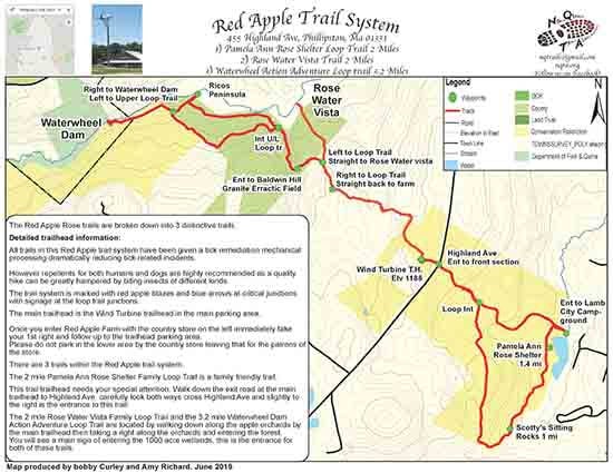
Red Apple Farm Trail System
Location
Map Legend

Icons on the map can be clicked to get directions on Google Maps (works best for Parking Icons).
Get the Map
This property is in NQTA Map #17. You can purchase NQTA Map Sets in our Shop.
Directions
All trails in this Red Apple trail system have been given a tick remediation mechanical processing dramatically reducing tick related incidents.
However repellents for both humans and dogs are highly recommended as a quality hike can be greatly hampered by biting insects of different kinds.
The trail system is marked with red apple blazes and blue arrows at critical junctions with signage at the loop trail junctions.
The main trailhead is the Wind Turbine trailhead in the main parking area.
Once you enter Red Apple Farm with the country store on the left immediately take your 1st right and follow up to the trailhead parking area.
Please do not park in the lower area by the country store leaving that for the patrons of the store.
There are 3 trails within the Red Apple trail system.
The 2 mile Pamela Ann Rose Shelter Family Loop Trail is a family friendly trail.
This trail trailhead needs your special attention. Walk down the exit road at the main trailhead to Highland Ave. carefully look both ways cross Highland Ave and slightly to the right is the entrance to this trail.
The 2 mile Rose Water Vista Family Loop Trail and the 3.2 mile Waterwheel Dam
Action Adventure Loop Trail are located by walking down along the apple orchards by the main trailhead then taking a right along the orchards and entering the forest.
You will see a main sign of entering the 1000 acre wetlands, this is the entrance for both of these trails.
Overview
The 2 mile Pamela Ann Rose Shelter family loop trail
Once entering this trail from Highland Ave, walk down along a recent forest cutting and take left on the cart road, shortly coming to the loop trail intersection.
The preferred way is take a right at this intersection, follow up a short ridge and continue until hearing the noise of route 2, then take a left, saying goodbye to the noise and bustle of the day.
Shortly take a right and follow until you come to a intersection this is for multi use take either way and follow out and you come to the wetlands.
Take a left and follow along the wetlands until you come out to the pond and the Pamela Ann Rose Shelter.
This is the major break spot and a spiritual hello in loving memory of my sister and the Rose family. ♥️
Continue on till you come to an intersection the left is the loop trail back, the right shortly takes you to the entrance to Lamb City campground.
Along this 2 mile loop trail you’ll be walking through different years of early successional forest cutting which is a long term scientific forestry plan in place by Bill Rose. You will see many witnesses of these different years of cutting.
The 1st section up to the ridge you will be walking through the mature cutting section and this is a wonderful blueberry and raspberry picking area.
It also allows for multi viewing of all sorts of small critters and many bird species.Take your time and enjoy the beauty and the forestry scientific value of this trail.
The 2 mile Rose Water Vista family loop trail
Enter the trail from the apple orchards and follow along until you come to the 2nd. intersection where a left takes you to the Waterwheel Loop Trail.
Go straight (not left) down through a set of granite erractics and to the stunning vistas of the peninsula.
There is a 150′ incline and decline to be prepared for.
This is a wonderful introduction trail for the family to go down to visit the wetlands and come back and have a true country experience with the children and family at the Red Apple farm with the animals and country store.
The 3.2 mile Waterwheel Dam Action Adventure loop trail
This is the true hikers hike and affords the full opportunity of seeing this stunning diversity of this trail system.
Enter the trail by following the same path of the Rose Water Vista trail and at the 2nd intersection take a left.
Follow trail down to a several hundred year old natural bridge crossing a brook and enter Baldwin Hill (break spot).
Shortly take a right at an intersection at Baldwin Hill and follow down through a beautiful series of granite erractics.
Be careful through this section with your footing especially when wet.
Follow the trail down to the 1000 acre wetlands where you come to the intersection and sign of the Upper / Lower loop trail.
The preferred way is to follow the Lower Loop Trail along these stunning wetlands and ensure you take the time to say hello to the beavers, wildlife and botany experiences.
Come out to Rico’s Peninsula and take the time for a nice break and wildlife viewing experience.
Coming from Rico’s follow up a slight incline and come out to the Upper loop trail intersection, take a right and follow trail to one of the most amazing archeological sites in the trail system, a several 100 year old early settlers Waterwheel dam.
Follow trail back up to the Upper Loop Trail intersection and follow along with many viewing opportunities along ridge looking down on the wetlands and back to the intersection of Upper/ Lower Loop Trail and up the 250′ worth of incline to the farm.
Again these trails have been tick remediated, blazed with red apples and signage and are available and open for some wonderful hiking experiences for all families and levels of hikers.
Photo Gallery